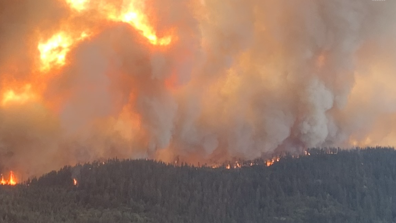
Image: BC Wildfire Service / The Kookipi Creek wildfire northwest of Boston Bar has grown another 750 hectares in the last 24 hours, according to the latest wildfire update. Additional, 85 firefighters have been assigned to fight the fire and 26 structure protection personnel have been assigned to this incident. 
Fire northwest of Boston Bar

Fire north of Boston Bar grows another 750-plus hectares; 85 firefighters assigned to Kookipi fire

Aug 23, 2023 | 2:01 PM

BOSTON BAR — The Kookipi Creek wildfire now exceeds 14,000 hectares in the latest update from the BC Wildfire Service.

According to its website updated Wednesday afternoon, August 23 at 12:23 p.m., the fire originally located northwest of Boston Bar is now 14,425 hectares.

It was previously 13,674 hectares as of Monday night (Aug. 21), 10,500 hectares on Saturday, August 19, and 8,791 hectares on Friday afternoon, August 18.

BCWS previously reported that an incident management team would assume command of the Kookpipi Creek wildfire starting Tuesday, August 22.

“Today, smoke posed a challenge for aerial resources, but it is expected to improve tomorrow,” BCWS wrote on its website about the Kookipi Creek wildfire on Tuesday, Aug. 22. “Crews continue to work hard to protect vital infrastructure including transmission lines, railways, and Highway 1, along with working to limit growth on the south and east portions of the fire.”

Structure protection is working in the Kanaka area to triage and setup apparatuses, as well as working on the south and eastern flank to protect vital infrastructure from Blue Lake down to Boothroyd, BCWS said.

BCWS is presently utilizing a slew of resources including 85 firefighters assigned to this fire, seven helicopters, an incident management team, 12 pieces of heavy equipment, and 26 structure protection personnel for this specific incident.

BCWS also reports the following:

  • A combination of an Initial attack crew and contract crews are working in and around the south flank on the west side of the Fraser River.
  • Yesterday, Aug. 22, ground crews were doing direct attack in two areas on the west side of the Fraser River and will continue that work today.
  • The first group is working north of Washtock Ranch. Crews are aiming to contain the fire between 4 Barrel Road and the Nahatlatch River, crews completed an edge on that section yesterday.
  • The other area of direct attack was along Keefer Road, where the fire is burning between Keefer Road and the Fraser River. Crews completed a fuel free in this area and then utilized direct attack methods. Work will continue today with the goal of having Keefer Road tied into the Nahatlatch River.
  • In the coming days, BCWS says its objective is to conduct roadside danger tree assessments and falling (DTA and DTF) along the Nahatlatch Forest Service Road (FSR), Keefer Road and 4 Barrel Road. This will be done to improve worksite safety and allow crews to conduct fire suppression safely along the road.
  • The control line that is adjacent he Nahatlatch FSR is complete from the Sandy Pines guard to the Robert’s Creek draw. Assessments will occur in the coming days to evaluate the need for an expansion of this guard further south to help defend values south of the Washtock Ranch.
  • The Sandy Pines guard is completed from the Washtock Ranch to the Fraser River.
  • Security check points are now in place along the Nahatlatch FSR 24 hours a day.
  • Structure protection personnel will be setting up structure protection equipment and triaging along the Nahatlatch FSR and Keefers Road.

East of the Fraser River on the southern flank:

  • A combination of two unit crews, an initial attack crew, and contract crews are working along the south and southeast flanks of the fire, on the east side of the Fraser River.
  • On Aug 21, on the southeastern flank, crews solidified the guard and set up a sprinkler line along the railway. Crews will continue to clean up the wetlines by removing unburnt fuels and tie the line in from the Nahatlatch River to Highway 1.
  • Daily assessments of danger trees in all areas where ground crews are is being completed, given the drought code and fire activity, hazards continue to be present
  • Yesterday, there were two spot fires over the Mohawkum guard that ground crews actioned and patrolled throughout the evening to extinguish remaining hot spots.
  • Today, ground crews will conduct mop up operations up to 100 feet of the fire perimeter and patrol for hot spots between Fraser River and Highway 1 on the southeast corner and between Highway 1 and Mohawkum FSR. A unit crew will be working on the east end of this guard while another works their way up from Highway 1.
  • Assessments of control line locations will continue above the Mokawkum FSR.
  • Structure protection personnel will be working from Boothroyd to Kanaka Bar, where they will patrol and action spot fires along Highway 1.

East of the Fraser River along the northern flank:

  • A combination of 2 unit crews and structure protection personnel will be working in the Kanaka Bar area today.
  • Structure protection personnel are working in and around the northeastern flank of the fire, focusing their work around the Kanaka Bar and Boothroyd areas, as well as the Nahatlatch area.
  • Last night, the wildfire crossed the Siwash Creek in higher elevation. There are no threats to Kanaka due to it crossing the creek.
  • On Aug. 22, the fire was more active on the northeastern flank and it did burn in close proximity to the pumphouse and to portions of the guard that was established around Kanaka Bar. Ground crews worked throughout the night and additional personnel will be deployed to the area today. Crews will work to bring the fire safely to the guard by removing unburnt fuels between the guard and the fire’s edge.
  • Assessments are underway above Kanaka Bar to determine how the fire can be tied into an old burn scar from 2021.
  • The western flank of the fire is burning in steep and inoperable terrain and scouting for potential ignition operations around Kwoiek Creek.
  • The wildfire will be closely monitored west of Highway 1 and Kanaka on the east side of the Fraser River to ensure it does not cross the highway.
Click here to report an error or typo in this article